
Canwell Group
Services
Engineering Service Portfolio
Canwell Group offers a wide range of engineering services and the ability to perform those services around the world. Our professionally trained staff offer our customers custom designed solutions to their most complex projects which may include:
- OSP Design & Engineering
- ISP Design & Engineering
- Fiber, Copper, & Wireless
- CADD Drafting
- Government & Commercial GIS/GPS Services
- Right-of-Way Engineering
- Right-of-Way Acquisition
- Site Surveys
- Facility Validation
- Permit Acquisition
- Feasibility studies
Our engineers bring decades of experience to the Design, Engineering and Implementation of advanced telecommunication projects. Canwell Group is widely recognized as an innovator in the communications and related industries. We bring a high level of technological know-how, innovation, quality and integrity to our projects, both large and small.
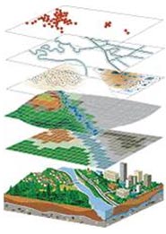
GIS/GPS Data Collection & Mapping
Utilizing the industries latest technology, equipment and software, the Canwell Group geospatial team is trained and experienced with the knowledge and understanding to respond to your government and commercial data needs.
Global Positioning Systems (GPS) is used for locating Geospatial Installation Services (GIS) features real time as they are installed or post implementation and include but are not limited to:
- Manhole & Conduit System Data Collection.
- Aerial & Underground Utility Data Collection.
- Government & Municipal Right of Way Data Collection.
Canwell Group GIS mapping systems are based on ESRI ArcGIS software family for problem solving that is quickly understood and easily shared between all users.
Our final GIS mapping delivery format can be in the form of ESRI Shapefiles, ESRI Geodatabase with relationship classes and domains, CADD, PDF, Images (.jpg, .gif, .png, .bmp, etc…), Google Earth and Google Map, and 3D views and animations.
Here at Canwell Group we use ESRI ArcPad software for GPS feature collection for easy ‘Check-out’ and ‘Check-in’ to ArcMap GIS mapping software. Our GPS data will be collected in a WGS-84 latitude and longitude projection and converted to a State Plane Coordinate System of the client’s choice. We comply with the Communications Feature Location Data (CFLD) and Spatial Data Standards for Facilities, Infrastructure, and Environment (SDSFIE) standards for government projects.